Due to its fast multi-element capability and excellent detection limit, Inductively Coupled Plasma Mass Spectrometry (ICPMS) is widely used for trace elements analysis in various fields including geology, environment, biology and medicine. A ThermoFisher ICPMS ( iCAP RQ) is recently installed in our department and will be come into service. In this context, the report presented an introduction of the capabilities and limitation of the ICPMS. Frist, comparisons of ICPMS and other element analytical techniques offer an insight of its advantages and drawbacks. Secondly, the basic principle, structure, major parts and their functions of the ICPMS were presented in detail. Finally, the applications of ICPMS in geology and other fields were given. In the interactive part of the report, Dr. Zhu Bi answered questions raised by students. The report offer an opptunity to better understand the applications and limitations of the instrument.

The report points out the importance of flow direction algorithms. Some commonly-used flow direction algorithms are introduced in terms of their principles, advantages and disadvantages, and are further classified based on their characteristics. A geometrical analysis is conducted for characterizing water movement on triangle facets. We summarize the necessary and sufficient elevation condition when an adjacent cell becomes a receiving cell, and the mathematical relations between the slope of triangle facet and the flow-partition fraction and effective contour length of receiving cell. Based on the results of geometric analysis, a TFGA-A method that assumes flow evenly distributed on triangle facets and a TFGA-B method that assumes flow unevenly distributed over routing pathways are proposed. The realistic terrains in natural watershed are represented by theoretical surfaces. The theoretical values for topography parameters on theoretical surfaces are deduced according to topographical concept of drainage area. A framework based on theoretical surfaces and topography parameters for evaluating the “value” and “location” accuracy of flow direction algorithms is developed. Results show that the value and position precision of topography parameters obtained by TFGA-B is much higher than those obtained by other algorithms. Due to distinguishing the differences between contributing area and influence area, the precision of TDA and SDA obtained by TFGA-B is one to two orders of magnitude higher than those of other algorithms.

Grain size of lake sediments is often measured in paleolimnological studies, especially investigations of past paleoclimatic and paleohydrologic changes. The implications of such measures, however, remain unclear, since watershed hydrology and the related transfer of materials to the lake are affected by local climate variables, hydrological shifts, and vegetation cover variables. Sediment from lakes in the middle reaches of the Yangtze River have apparently been affected by land cover changes and lake-river system transitions caused by a sluice gate. These changes influenced the watershed hydrology, thereby confounding paleoclimatic and paleohydrologic interpretations by proxy records in sediment cores. The different relationships patterns that the sediments in the lake were not only transported following precipitation and discharge from the lake catchment but also came from the Yangtze River draining back into the lake during the flood seasons before. These results highlight matters needing attention and the potential application of grain size of sediments for reconstructions of past hydro-environmental changes.

Navigation receiver is easy to be restricted by harsh environmental factors in the application of emerging industries, which leads to the decline of positioning robustness and accuracy. The classical architecture of independent processing of traditional receiver signal and information module is improved, and the parameters of navigation signal such as amplitude, code phase and carrier are expanded by first-order partial derivative Taylor expansion. This method not only reduces the computational complexity of nonlinear functions, but also maintains the accuracy of information. On the basis of making full use of channel correlation, ranging code and carrier coupling correlation, a new receiver architecture based on direct location domain is constructed. The experimental results show that the new fusion method has better positioning and speed measurement accuracy than the traditional method in the occlusion, multipath, fading and other environments. The new architecture avoids the loss of useful signals from the source of information, which represents the development direction of navigation receiver in the future.
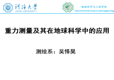
This report starts with the concept of gravity and the technique of gravimetric measurements. Dr. Wu introduces the applications of gravimetry in mass transportation, lake level variation, and dynamic topography modeling. Aiming at solving the problem of signal leakage and distortion in mass transportation from GRACE, this report focuses on the so-called methods like Mascon and RBF for high-resolution mass transportation modeling. Moreover, Dr. Wu introduce the recently progress of lake level monitoring from heterogeneous altimetry data, and the dynamic topography modeling from satellite altimetry, gravimetry, and in-situ data. Through this academic exchange, we have a further understanding of satellite gravimetry and satellite altimetry.

The report from Dr. Rui Huang focused on the nitrogen-removing microorganisms in the riparian of Taihu Lake and details the distribution pattern, community assembly and co-existence relationships within the microbial communities and denitrifiers under the influence of aquatic plants. By investigating the microbial community in the rhizosphere of typical aquatic plants in the riparian, this reported work revealed the importance of emergent and submergent macrophytes in determining the community composition of rhizospheric bacteria, and demonstrated that macrophytes can significantly increase the richness and diversity of denitrifying microorganisms. In addition, the competitive exclusion pattern between nitrite-reducing microbial species among denitrification community was verified by network analysis. Meanwhile, the niche partitioning between two clades of nitrous oxide reduction microorganisms were confirmed through the comparison of community assembly. These findings would direct to understanding and manipulating the nitrogen removal process mediated by microorganisms in the riparian zone of freshwater ecosystem.
Dr. Yuanhao Fang presented his research on improving the representation of hydrological processes in two land model, i.e., Noah-MP in National Water <odel and E3SM Land Model. In the first part of his presentation, Dr. Fang showed his efforts to improve the snowmelt runoff in National Water Model by considering the topographic effects on incoming solar radiation. His proposed scheme ensures a more realistic simulation of land surface energy balance which benefits the snow melt runoff estimation. Then Dr Fang introduced his efforts to develop a lateral flow scheme in E3SM Land model using hillslope conception. The new scheme is able to reproduce the subgrid variability of water table and lateral flow which helps to better understand global water and energy cycles.

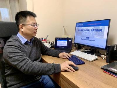
China is suffering from geohazards, and near three-quarters of the country's land area are geohazard-prone areas. Geohazards such as landslides occur thousands of times throughout the country every year. Knowing where is the hidden danger point and when may it happen is the core requirement for the prevention of geohazards. Based on a brief introduction of synthetic aperture radar interferometry (InSAR), Dr Xiao Ruya focused on the framework of rapid survey and update of geohazards in wide-area using Earth observations, as well as the challenges and countermeasures in practical applications. He discussed in detail the statistical assessment indicators for InSAR atmospheric correction, and GACOS-assisted (Generic Atmospheric Correction Online Service for InSAR) InSAR stacking and time series analysis methods. Dr Xiao also introduced the latest research trends in radar remote sensing in European universities and research institutions.